
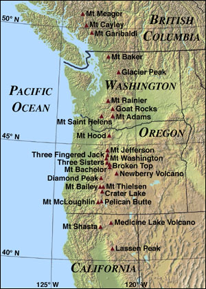
At its southern end the range is about 30 to 50 miles (50 to 80 km) wide and 4,500 to 5,000 feet (1,370 to 1,520 m) high and 80 miles (130 km) wide in northern Washington. At its northern apex at Lytton Mountain (2,049 m) in Canada, near the confluence of the Fraser and Thompson Rivers, the range is only 10 miles (16 km) wide. The tallest volcanoes of the Cascades are called the High Cascades and dominate their surroundings, often standing twice the height of the nearby mountains. They often have a visual height (height above nearby crestlines) of one mile (1.6 km) or more. The tallest peaks, such as the 14,411 foot (4,392 m) high Mount Rainier, dominate their surroundings for 50 to 100 miles (80 to 160 km).
The northern part of the range, north of Mount Rainier, is known as the North Cascades. It is extremely rugged, with many of the lesser peaks steep and glaciated. The valleys are quite low, resulting in great local relief, and major passes are only about 1,000 m (3,300 ft) high. The southern part of the Canadian Cascades are included in the North Cascades, and have the same geography and geology. Usage differs as to whether to include the Coquihalla Range, which reaches up to the confluence of the Fraser and Thompson Rivers, and which has very different terrain and geology, more resembling the plateau country which extends north and east from the range's terminus at Lytton Mountain.
Because of the range's proximity to the Pacific Ocean, precipitation is substantial, especially on the western slopes, with annual accumulations of up to 150 inches (3,800 mm) in some areas—Mount Baker, for instance, recorded the largest single-season snowfall on record in the world in 1999—and heavy snowfall as low as 2,000 feet (600 m). It is not uncommon for some places in the Cascades to have over 200 inches (5,500 mm) of snow accumulation, such as at Lake Helen (near Lassen Peak), one of the snowiest places in the world. Most of the High Cascades are therefore white with snow and ice year-round. The western slopes are densely covered with Douglas-fir, Western Hemlock and Red alder, while the drier eastern slopes are mostly Ponderosa Pine, with Western Larch at higher elevations. Annual rainfall drops to 8 inches (200 mm) on the eastern foothills due to a rainshadow effect.
Beyond the foothills is an arid plateau that was created 16 million years ago as a coalescing series of layered flood basalt flows. Together, these sequences of fluid volcanic rock form a 200,000 square mile (520,000 km²) region out of eastern Washington, Oregon, and parts of Northern California and Idaho called the Columbia River Plateau.
The Columbia River Gorge is the only major break in the American part of the Cascades. When the Cascades started to rise 7 million years ago in the Pliocene, the Columbia River drained the relatively low Columbia River Plateau. As the range grew, the Columbia was able to keep pace, creating the gorge and major pass seen today. The gorge also exposes uplifted and warped layers of basalt from the plateau.
From "Cascade Range" on [
Wikipedia]
No comments:
Post a Comment